
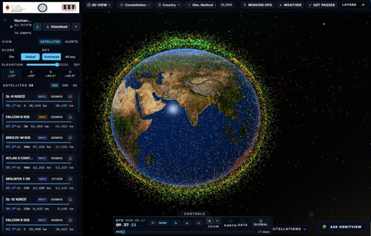
SPINOrbit — Satellite Tracking & Intelligence Platform
Project Overview: A GIS- and space-enabled intelligence platform designed to support live satellite tracking, orbital pass prediction, India-focused weather and flood intelligence, disaster context, launch monitoring, and space-weather awareness in one operational console.
Problem Statement: Traditional space and disaster workflows often rely on separate tools for satellite catalogs, pass prediction, weather forecasts, flood risk, launch schedules, and space weather. This leads to fragmented data, weak geographic context for India, slow decision cycles, and limited trust in whether information is live, modelled, or officially observed.
Proposed Solution: Developing an integrated digital platform that combines real-time orbital visualization, Space-Track / TLE catalog management, ground-location pass simulation, India weather and flood intelligence (with evidence and provenance), disaster and launch intelligence, and space-weather dashboards—so operators can track assets, anticipate passes, and assess risk from one screen.
Major Features
Live 3D / globe satellite tracking with filters (category, constellation, country, orbit).
Full TLE catalog sync (Space-Track with CelesTrak fallback) and observer location pinning.
Satellite Pass Simulator with analytics (KPIs, elevation, duration, upcoming passes).
India Weather Intelligence — map layers, forecast/hazards workspace, state-level context.
Flood Intelligence — risk overview, drivers, evidence chain, river / satellite / forecast tabs.
Disaster Intelligence — model vs observation context and exposure-oriented views.
Launch Intelligence — catalog, calendar, timeline, sites, and rockets.
Space Weather dashboard — current conditions, alerts, and history (NOAA SWPC–style feeds).
Imagery / external data hooks (e.g. Bhoonidhi-style search) tied to location.
Provenance badges (Live / Demo / Modelled / Official) and role-ready admin/API surfaces.
Technologies and Tools
Frontend: React.js, Vite, Cesium / 3D globe, React Query, Recharts.
Backend: FastAPI (Python), Uvicorn.
Data / cache: Redis (optional), disk cache, SQLite for selected catalogs.
GIS & geospatial: Map layers, state framing, GeoJSON / satellite extent overlays.
External APIs: Space-Track, CelesTrak, Open-Meteo, Copernicus EMS, GDACS, NOAA SWPC, launch feeds.
Cloud: AWS (EC2, S3, CloudFront), nginx, Let’s Encrypt / HTTPS.
Mobile / clients: Responsive web (Flutter not primary; web-first ops UI).
Integration: REST APIs, CI/CD (GitHub Actions).
Practical Applications
Satellite situational awareness for India-focused ops and research.
Ground-station / field pass planning for weather and Earth-observation satellites.
Municipal and state weather–flood briefing with model vs official evidence.
Disaster preparedness and situational monitoring.
Launch schedule and mission awareness.
Space-weather awareness for satellite, GNSS, and HF/ops planning.
Training and demonstration of integrated space–weather–disaster intelligence.
Let's Build the Future With Us
Whether you are a researcher, startup, industry partner, government organisation, academic institution, or student, IITTNiF provides opportunities to innovate, collaborate, develop technologies, and create national impact.