
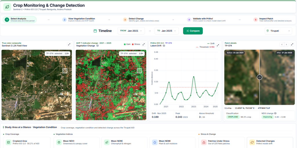
Project Overview
The Crop Monitoring & Change Detection System is a satellite-based geospatial intelligence platform designed to monitor vegetation health, identify potential land-cover changes, and assess agricultural conditions over time. By integrating multi-temporal Sentinel-2 imagery, the Prithvi-EO-2.0 Earth observation foundation model, vegetation indices, and Analytic Hierarchy Process (AHP)-based assessment, the platform provides spatial and temporal insights through an interactive GIS dashboard.
Problem Statement
Agricultural monitoring often depends on periodic field surveys and fragmented satellite-analysis workflows. This makes it challenging to assess vegetation health consistently, identify seasonal changes, and locate areas requiring further investigation. A unified geospatial platform can integrate satellite observations, vegetation indicators, and temporal analysis to improve agricultural monitoring.
Our Approach
Acquire → Preprocess → Analyze → Detect Change → Visualize
The system processes multi-temporal Sentinel-2 imagery using cloud and shadow masking, reflectance preprocessing, and vegetation-index calculation. Frozen Prithvi-EO-2.0 embeddings support crop classification and latent change detection. An AHP-based methodology combines seven vegetation indices into a composite Vegetation Health Score (VHS), while annual comparison overlays and interactive visualizations support temporal analysis.
Core Functionality
- Multi-temporal Sentinel-2 imagery processing
- Prithvi-based geospatial feature extraction
- Latent change detection using cosine distance
- Crop and non-crop patch classification
- Vegetation-index calculation and analysis
- AHP-based vegetation health assessment
- Annual vegetation change overlays
- Patch-level inspection
- Multi-year monitoring across five study areas
Technologies Used
Python, Sentinel-2 Satellite Imagery, Prithvi-EO-2.0, PyTorch, Google Earth Engine, Rasterio, NumPy, NDVI, EVI, SAVI, MSAVI, DVI, RVI, ARVI, and Analytic Hierarchy Process (AHP).
Results & Impact
The platform provides an integrated workflow for monitoring vegetation conditions and investigating potential agricultural changes across Tirupati, West Godavari, Anantapur, Krishna, and Guntur in Andhra Pradesh. Satellite-derived indicators, foundation-model analysis, and temporal visualization support crop monitoring, vegetation-health assessment, and data-driven land-condition analysis.
Target Users
- Agricultural monitoring departments
- Remote sensing and GIS analysts
- Government agriculture departments
- Crop and land-use researchers
- Environmental monitoring teams
- Geospatial intelligence teams
- Agricultural planning and assessment personnel
Technical Challenges
Maintaining consistent multi-temporal satellite preprocessing, handling cloud-contaminated and missing pixels, integrating foundation-model embeddings with downstream classifiers, calibrating change-detection thresholds, and ensuring reliable spatial and temporal comparisons.
Operational Challenges
Managing differences in satellite acquisition dates and seasonal conditions, validating crop classifications against independent reference data, interpreting vegetation-index variations, and distinguishing actual land-cover changes from seasonal or atmospheric effects.
Let's Build the Future With Us
Whether you are a researcher, startup, industry partner, government organisation, academic institution, or student, IITTNiF provides opportunities to innovate, collaborate, develop technologies, and create national impact.