
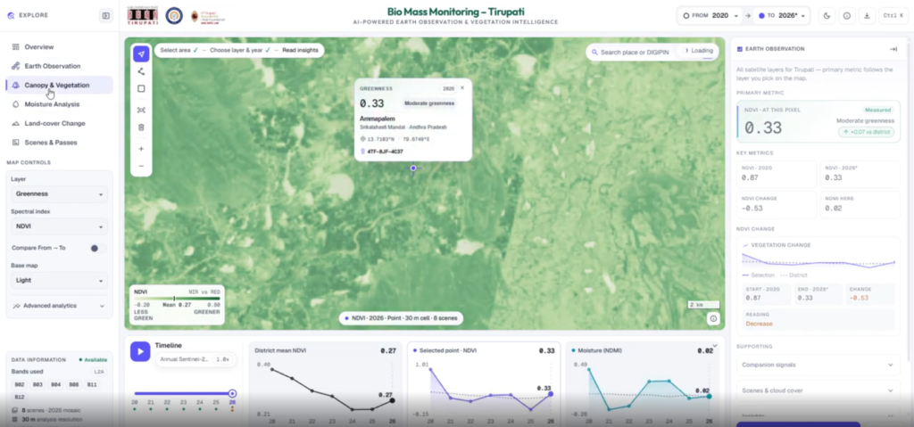
Project Overview
The AGB–Prithvi System is a satellite-based geospatial intelligence platform designed to analyze vegetation patterns and support above-ground biomass (AGB) estimation using Earth observation data and foundation-model representations. The workflow integrates Sentinel-2 satellite imagery from Microsoft Planetary Computer, the Prithvi-EO-2.0 foundation model, GEDI biomass reference data, and machine learning regression to support spatial analysis, annual mapping, and vegetation-change assessment.
Technologies Used
- Python
- Sentinel-2 Satellite Imagery
- Microsoft Planetary Computer
- Prithvi-EO-2.0 Foundation Model
- PyTorch
- GEDI Biomass Reference Data
- Random Forest and XGBoost
- Multilayer Perceptron (MLP)
- Rasterio and NumPy
- GeoPandas
- Optuna
- Geospatial Raster Processing
- Spatial Validation and Time-Series Analysis
- Flask and MapLibre for Dashboard Visualization
Problem Statement
Monitoring forest biomass and vegetation changes across large geographical areas requires consistent satellite observations, reliable reference data, and validated analytical workflows. Fragmented processing methods, spatial inconsistencies, and limited ground-reference measurements can make accurate biomass estimation and year-to-year comparisons challenging. An integrated geospatial platform can combine satellite imagery, foundation-model features, regression techniques, and spatial analysis to support systematic environmental monitoring.
Our Approach
Acquire → Preprocess → Extract Features → Train → Validate → Map → Analyze → Visualize
The system acquires multi-temporal Sentinel-2 imagery and performs cloud masking, band selection, reflectance preprocessing, spatial alignment, and temporal compositing. The Prithvi-EO-2.0 foundation model extracts geospatial representations from compatible satellite patches. Machine learning regression models use these embeddings and reference biomass observations to estimate AGB where suitable reference data and validation are available. Annual maps, change-detection layers, and hotspot analysis support spatial and temporal investigation through an interactive dashboard.
Core Functionality
- Multi-temporal Sentinel-2 satellite data processing
- Automated raster quality checks and preprocessing
- Prithvi-EO-2.0 feature extraction and embedding generation
- GEDI reference biomass integration
- Spectral and vegetation-index baseline modeling
- Random Forest, XGBoost, and MLP regression
- Spatially separated model training and validation
- Annual vegetation and biomass mapping where supported
- Biomass gain, loss, and change analysis
- Spatial hotspot identification
- Model performance comparison and visualization
- Interactive geospatial dashboard with year-wise map exploration
Results & Impact
The system provides an integrated workflow for satellite-based vegetation monitoring, foundation-model feature extraction, and geospatial change analysis. It supports the comparison of vegetation conditions across years and establishes a reproducible framework for biomass estimation, model evaluation, and spatial analysis when suitable reference data are available.
Current limitation: The documented Tirupati implementation generates annual vegetation-index maps, spectral-pattern maps, and Prithvi-derived representations for 2020–2026, with 2026 representing a partial year. Validated AGB estimates in tonnes per hectare have not been produced because suitable local field biomass reference data are unavailable. Biomass regression metrics and validated biomass change maps therefore remain pending.
Target Users
- Forest and environmental monitoring departments
- Remote sensing and GIS analysts
- Forestry researchers
- Climate and carbon-monitoring teams
- Government environmental agencies
- Geospatial intelligence teams
- Land-use and ecosystem researchers
Technical Challenges
Maintaining consistent multi-temporal satellite preprocessing, ensuring compatibility between Sentinel-2 bands and the selected Prithvi checkpoint, managing cloud-contaminated and missing pixels, aligning GEDI observations with satellite patches, extracting reusable embeddings, and preventing spatial or temporal data leakage during model validation.
Operational Challenges
Obtaining reliable biomass reference measurements, handling differences in satellite acquisition dates and seasonal conditions, validating regression performance across independent spatial regions, distinguishing vegetation-index changes from actual biomass changes, and maintaining reproducible outputs across supported years.
Let's Build the Future With Us
Whether you are a researcher, startup, industry partner, government organisation, academic institution, or student, IITTNiF provides opportunities to innovate, collaborate, develop technologies, and create national impact.