
Project Overview
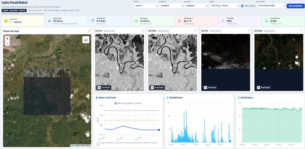
The Flood Monitoring & Prediction System is an AI-enabled geospatial platform that integrates satellite imagery, hydro-meteorological observations, and machine learning to support flood-risk assessment and inundation monitoring. By combining Sentinel-1 Synthetic Aperture Radar (SAR), Sentinel-2 multispectral imagery, and environmental sensor data, the platform enables water-extent change detection, flood-risk analysis, and data-driven early-warning support.
Problem Statement
Flood-prone regions face challenges in monitoring changing water levels, identifying newly inundated areas, and delivering timely flood-risk information. Conventional monitoring methods may have limited spatial coverage or depend on delayed observations. Integrating remote sensing, environmental data, and predictive analytics can improve situational awareness and disaster preparedness.
Our Approach
Collect → Preprocess → Detect → Predict → Visualize
The system integrates Sentinel-1 SAR and Sentinel-2 optical imagery with environmental observations, including rainfall, humidity, soil moisture, temperature, water levels, and discharge. A Clay geospatial foundation model supports satellite feature extraction and analysis. Pre- and post-flood imagery is processed to identify water extent and potential inundation changes, while machine learning models such as XGBoost and LSTM can analyze historical and environmental observations for flood-risk estimation. An interactive GIS dashboard presents flood maps, hydrological trends, and prediction outputs.
Core Functionality
- Sentinel-1 SAR and Sentinel-2 optical data integration
- Pre- and post-flood water-extent change detection
- SAR preprocessing and Otsu-based water classification
- Identification of existing water, newly inundated areas, and receded water
- Environmental and hydrological sensor integration
- Machine learning-based flood-risk prediction
- Interactive GIS-based flood-risk maps
- Environmental time-series visualization
- Station-based monitoring and historical flood-event replay
- Flood-risk indicators and early-warning decision support
Technologies Used
Python, React, XGBoost, LSTM, Google Earth Engine, Sentinel-1 SAR, Sentinel-2 Multispectral Imagery, Clay Geospatial Foundation Model, Rasterio, NumPy, SciPy, Scikit-image, GIS, Leaflet, REST APIs, and Time-Series Analysis.
Results & Impact
The platform brings satellite observations, environmental measurements, and predictive analytics into a centralized monitoring dashboard. It supports visualization of water-extent changes, monitoring of hydrological conditions, identification of potential flood-risk patterns, and evidence-based disaster preparedness.
Prediction accuracy and operational effectiveness should be reported using validated test results and real-world evaluations.
Target Users
- Disaster management authorities
- Government and local administration
- Hydrological researchers
- Environmental monitoring agencies
- Flood response teams
- Emergency planning organizations
- Remote sensing and GIS analysts
Technical Challenges
Integrating heterogeneous satellite and sensor datasets, managing SAR speckle noise and NoData regions, aligning pre- and post-event imagery, selecting suitable water-detection thresholds, extracting reliable spatial features, and combining spatial observations with temporal data for flood-risk prediction.
Operational Challenges
Obtaining consistent satellite observations and reliable ground-truth flood masks, managing missing sensor readings, distinguishing actual inundation from radar-related false detections, and validating predictions across different flood events and monitoring stations.
Let's Build the Future With Us
Whether you are a researcher, startup, industry partner, government organisation, academic institution, or student, IITTNiF provides opportunities to innovate, collaborate, develop technologies, and create national impact.