
Project Overview
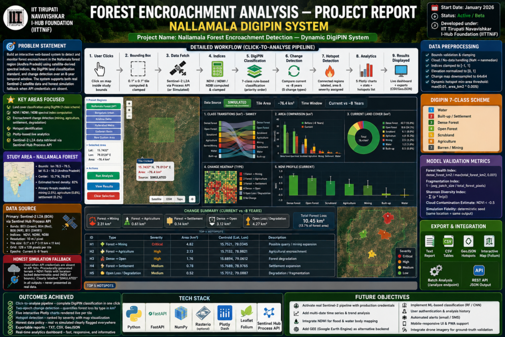
The Forest Encroachment Monitoring System uses satellite imagery and geospatial analysis to support the identification and monitoring of forest-cover changes. By processing multi-temporal Landsat and Sentinel-2 data, the platform supports the analysis of potential forest loss, land-cover changes, and vegetation trends for environmental monitoring.
Technologies Used
- Python
- Flask
- HTML
- CSS
- JavaScript
- Landsat Data
- Sentinel-2 Data
- OpenStreetMap (OSM)
- Geospatial Analytics
- DigiPIN Integration
Problem Statement
Monitoring forest encroachment and land-cover changes over large geographic areas is challenging because of cloud cover, differences in image resolution, seasonal variations, and the effort required for repeated satellite-image analysis. A geospatial monitoring platform can help identify areas requiring further investigation.
Our Approach
Acquire → Analyze → Detect → Monitor
The platform combines multi-temporal Landsat and Sentinel-2 imagery with geospatial processing and change analysis. It supports the identification of changes in forest cover, visualization of affected areas, and location-based analysis using mapping and spatial indexing capabilities.
Core Functionality
- Multi-source satellite data integration
- Forest-cover change detection
- Encroachment monitoring
- Vegetation analysis
- DigiPIN-based location tagging
- Interactive geospatial mapping
- Historical trend analysis
- Alert generation, where implemented
Results & Impact
The system supports forest monitoring, change assessment, and location-specific environmental analysis. Its satellite-based approach can help conservation teams identify areas for further field verification and support evidence-informed environmental planning.
Target Users
- Forest departments
- Environmental monitoring agencies
- Conservation organizations
- Remote sensing researchers
- Geospatial analysts
- Government planning departments
- Environmental research institutions
Technical Challenges
Processing multi-temporal Landsat and Sentinel-2 imagery while accounting for cloud cover, seasonal vegetation changes, and differences in spatial resolution to produce meaningful change assessments.
Operational Challenges
Providing timely location-specific information, validating potential encroachment through field observations, and supporting conservation and policy-planning workflows.
Let's Build the Future With Us
Whether you are a researcher, startup, industry partner, government organisation, academic institution, or student, IITTNiF provides opportunities to innovate, collaborate, develop technologies, and create national impact.